You are browsing camaro5 

|
 10-27-2012, 12:20 AM
|
#1 |
|
Banned
Drives: Camaro SS Edition Join Date: Mar 2012
Location: New York
Posts: 6,840
   |
Camaro Owners Be Safe In New Jersey Hurricane Sandy
 Became a category 2 storm this morning.AFP PHOTO/NOAA The threat of a powerful, and perhaps unprecedented, hybrid storm government officials have dubbed a Frankenstorm affecting New Jersey in the coming days is still increasing, even if its exact impacts and location continues to confound forecasters across the nation this morning. Hurricane Sandy, a category 2 storm with winds of 105 mph, is churning north through toward the Bahamas this morning and is a key player in just how bad our weather will be from Sunday into mid-week. Forecasters at the National Weather Service warn that Sandy is forecast to track north up the eastern seaboard and potentially merge with a developing noreaster, creating a powerful hybrid storm that has the potential to have devastating impacts along the Mid-Atlantic and New England coastlines. "The lions share of guidance indicates that the circulation associated with Hurricane Sandy will pass close enough to the amplifying polar trough over the eastern United States to become incorporated into a hybrid vortex over the Mid-Atlantic and Northeast next Tuesday, the Hydrometeorological Prediction Center wrote in its morning forecast discussion. "The high degree of blocking from Eastern North America across the entire Atlantic Basin is expected to allow this unusual merger to take place inviting perhaps the ghoulish nickname for the cyclone along the lines of Frankenstorm." A myriad of scenarios for how the situation will unfold exists, according to forecast guidance. Were Sandy to track inland just south of or on the New Jersey coast, major coastal flooding, hurricane force winds and torrential rain are all distinct possibilities. A track further to the north, in New England, and the Garden State may be spared some of the more severe impacts. Even the potential for Sandy to move out to sea (while the least likely) cant be completely discounted at this point. Because the ceiling of the storms impact is so high, forecasters and state officials are urging residents to monitor it closely. The threat of major coastal flooding, inland flooding and wind damage is very much in the realm of possibilities for New Jersey a threat that should not be taken lightly, regardless of the outcome. 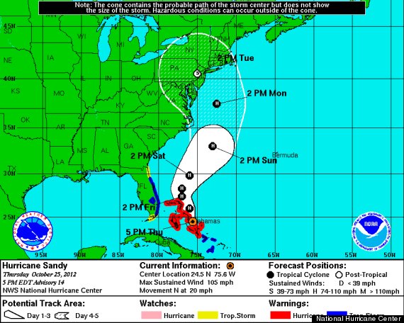
|

|

|
|
10-27-2012, 05:44 AM
|
#2 |
 Drives: 2013 2LT/RS Join Date: Jun 2012
Location: Nj
Posts: 98
|
part of me is happy i don't have my car yet lol
|
|
|
|
|
10-27-2012, 05:49 AM
|
#3 |
|
Camaro owner since 1982
Drives: 2012 Camaro 2SS-RS Conv IBM L99 Join Date: Jul 2009
Location: PA
Posts: 1,651
|
Its going to hit PA also, keep everyone safe and tuck your Camaro away!
__________________
 2012 Camaro RS-SS Conv IBM, L99 2012 Camaro RS-SS Conv IBM, L991968 Camaro RS Coupe 327 AT 1968 Camaro RS-SS Conv, sold 1993 |
|
|
|
|
10-27-2012, 05:51 AM
|
#4 |
|
Chillin Like a Villain

Drives: 2013 2SS Blue Ray Metallic Dusk Ed. Join Date: Apr 2011
Location: Clarksburg,MD
Posts: 551
|
on sunday im parking my car in the school parking garage(im in college) so it will be nice and safe!

|
|
|
|
|
10-27-2012, 01:02 PM
|
#5 | |
|
dey see me rollin

Drives: the magic school bus Join Date: Feb 2011
Location: Vault 101
Posts: 823
|
Quote:
|
|
|
|
|
|
10-27-2012, 01:03 PM
|
#6 | |
|
Banned
Drives: Camaro SS Edition Join Date: Mar 2012
Location: New York
Posts: 6,840
|
Quote:
 That's cold.. my friend works Amtrak out their. They constantly have to look at the weather. That's cold.. my friend works Amtrak out their. They constantly have to look at the weather.
|
|
|
|
|
 |
|
|